How do we transform our city's streets to shape the neighbourhoods Melburnians want? Michael Fendel, our intern looking at values-based modelling of our Streets, shares the seven key building blocks of what communities value about the places they live, work and play.
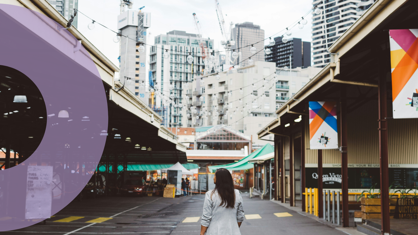
Over the last 12 months, we've walked the streets of the west with groups of students, gathered community and decision-makers on a popular Melbourne laneway, sat with a group of passionate residents in Kensington, brought representatives of the system into one room to workshop and created a pop-up green space in an unusual concrete place in Melbourne's CBD.
Through these countless conversations, workshops and community consultations, Regen Streets has captured a vast set of values that are a snapshot of what people and community groups around Melbourne cherish about their streets – and what they envisage for a better future. These values can be a starting point for communities and decision-makers alike to create a network of regenerative streets and neighbourhoods all over greater Melbourne.
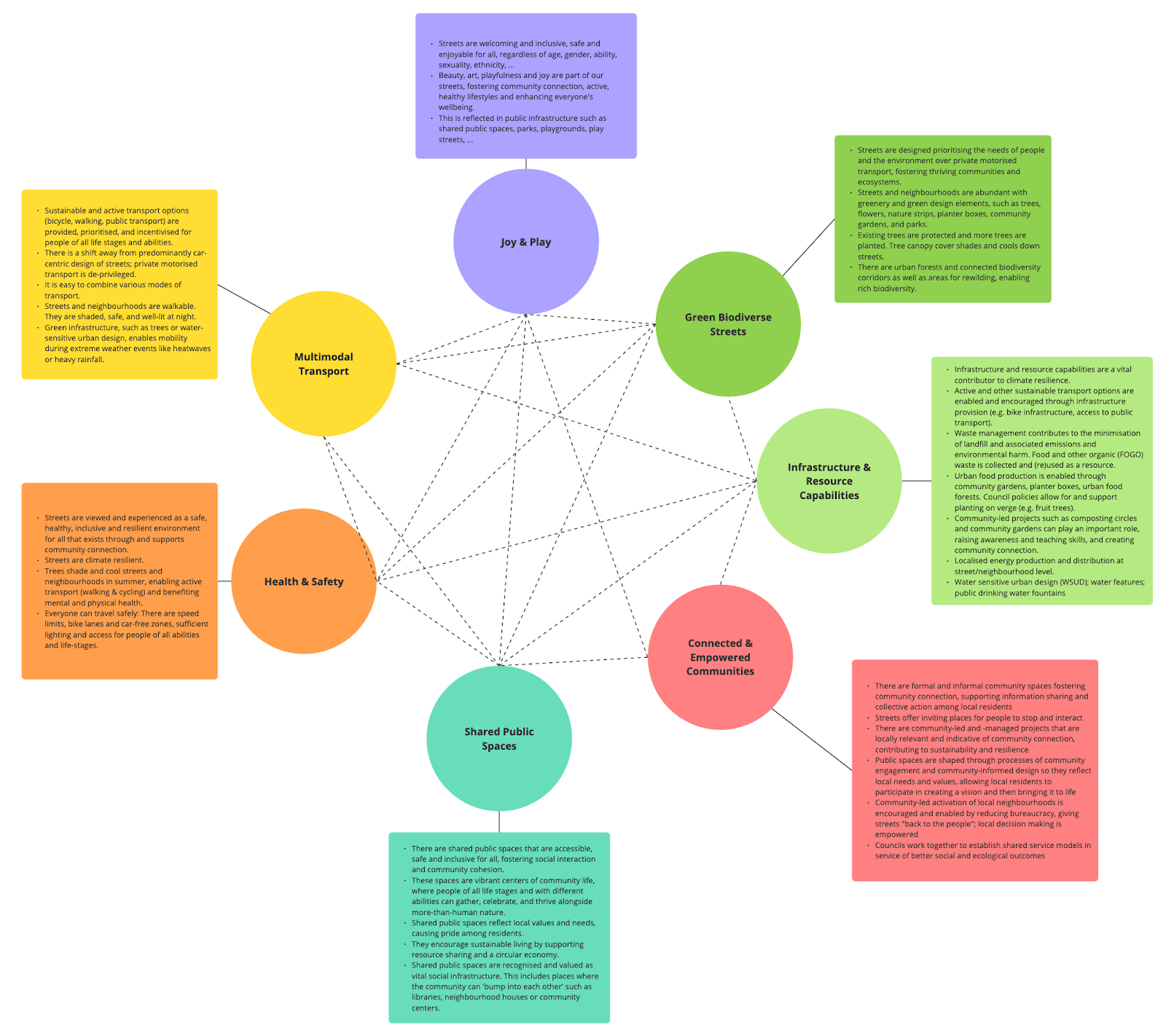
Out of all the information we captured, we distilled seven core building blocks (or should we say pavers?), encompassing the community-defined values for regenerative streets.
Is this a complete and perfect list? No. Will it change over time? Certainly. We consider this to be an evolving collection that develops with the conversations we hope to start.
Measuring What Really Matters
We know that what we value and invest in today does not sufficiently address the needs of future generations. How can we shift what we value on our streets based on goals that prioritise social and ecological wellbeing? Which tools and indicators could we use to better measure how we are tracking on our journey towards a regenerative future for our streets and the entire city?
There are plenty of innovative approaches that can inspire us, and that we can draw from, to create a holistic approach to measuring what really matters. We have compiled a few examples that cut across the seven core values listed above.
Bumping Up 'Bumping Spaces'
There are places that can help people connect by making it easier to simplybumpinto others: so called bumping spaces. These places are local, neutral and accessible to everyone. This includes public libraries, neighbourhood houses and community centres, but also markets, skateparks and other places where a diverse range of people can meet and interact.
Bumping spaces play an important role in building connected communities. They help combat loneliness and foster social connection, which is essential to people's health and wellbeing and can be helpful in case of emergencies or when people are in need of help.
Research shows that particularly in the rapidly growing new suburbs on the outskirts of Melbourne – where diverse, multi-cultural and often socioeconomically disadvantaged communities settle – those bumping spaces can be rare or hard to reach, due to a lack of public transport or because residents do not feel safe going out at night.
But it is precisely those suburbs and communities that need social infrastructure: places that help build social cohesion and resilience in the face of heightened climate vulnerability.
While it takes time to advocate for, plan and deliver places like public libraries and community centres, there are interventions that can provide communities opportunities to bump into each other. Consider a street party organised by residents, or a community garden that is accessible and welcoming to everyone. Or look at Merri-bek Council's Play Street program, where residential streets are officially blocked off from traffic for a few hours to create a safe space for children and neighbours of all ages to play.
This measure addresses the following Regen Streets values: Shared Public Spaces, Connected & Empowered Communities, Health and Safety, Joy & Play.
20-Minute Neighbourhoods
The idea of a 20-minute neighbourhood is that almost everything people need in their day-to-day life should be no more than a 20-minute return walk (on average, that is no more than 800 metres) away from their home. This includes grocery shops, schools and childcare centres, pharmacies and primary healthcare services, as well as green spaces.
The Victorian government has created a set of criteria to support the long-term planning and creation of a city of 20-minute neighbourhoods.
They should:
Be safe, accessible and well connected for pedestrians and cyclists to optimise active transport.
Facilitate thriving local economies
Support climate resilient communities
Provide high quality public realm and open spaces
Deliver housing/population at densities that make local services and transport viable
Provide services and destinations that support local living.
Applying this framework to all parts of our city will deliver significant health, social, economic and environmental benefits.
Do you live in a 20-minute neighbourhood? What is missing? How could it be improved?
Healthy Streets
The Healthy Streets approach is a human-centred framework for embedding public health in transport, public realm and planning.
The approach is based on 10 indicators, each describing an aspect of the human experience of being on streets. These include:
Everyone feels welcome
Easy to cross
Shade and shelter
Places to stop and rest
Not too noisy
People choose to walk and cycle
People feel safe
Things to see and do
People feel relaxed
Clean air
There are tools and resources available to assess streets against those indicators. This can be used by designers, planners and engineers to assess a design or project. But everyone else can use simple online survey tools to score how any given street performs against the 10 indicators.
This tool can be a great starting point for individuals and communities, planners and councils – for conversations and for taking steps towards healthier and more liveable streets.
Melbourne's Climate Resilience Index And Heat Score
While annual average temperatures get hotter and there are more extreme weather events such as heatwaves, bushfires, deluges and flooding, some parts of our city are more heavily affected than others.
The Climate Resilience Index(developed by Tract) is a tool to assess the capacity of Melbourne's neighbourhoods to effectively deal with climate change. To establish a neighbourhood's score, four key determinants are considered: amenities; transport and movement; environment and biodiversity; and hazard resilience.
Other related research identifies the parts of greater Melbourne that heat up the most due to large amounts of built surface and a lack of cooling tree canopy cover. Unsurprisingly, the densely built inner city registers with a high heat score. In contrast, the wealthy, "leafy" eastern suburbs are much cooler.
Both scores clearly show how risks associated with climate change and the capacity to deal with these risks are unevenly distributed. Particularly, outer suburbs in the west and south-east of Melbourne and the rapidly expanding growth corridors are affected by factors like extreme heat and not sufficiently set up to deal with this.
Planting more trees is only one, albeit important and effective, step to address this. Providing amenities and adequate transport and mobility options, prioritising environment and biodiversity, and improving hazard resilience across greater Melbourne are vital steps towards increased climate resilience and a safe and just city for all.
Tree Canopy Coverage And The 3-30-300 Benchmark
There is a strong case for increasing the amount of public trees in cities. Trees help reduce the urban heat island effect. This is especially critical during heatwaves in summer. Trees can essentially help cool down streets and whole neighbourhoods, making them more climate resilient, healthier and more liveable. Studies show that trees in public spaces benefit the mental health of the wider population.
Tree coverage is also a question of inequity. There is a well documented relationship between public tree coverage and the cost of housing across Melbourne. Not only can wealth buy you a large backyard, but it can also buy you direct access to those "leafy" suburbs with a greener public realm.
A safe and just Melbourne for all needs to provide sufficient greening of public spaces – not only in wealthy suburbs, but also in more disadvantaged areas, such as the growth corridors that already today are more vulnerable to heat waves and other extreme weather events.
The 3-30-300 benchmark builds on this. It is a metric that sets minimum standards for access to nature in cities. It specifies that homes, schools and workplaces should have a view of 3 trees, be in a neighbourhood with over 30% tree canopy cover and be within 300 metres walk of a park. RMIT Research, Thami Croesser has been leading some impressive local knowledge around this measurement as a goal for cities.
What next?
Obviously, there are many approaches to measuring what really matters: a thriving city socially, economically, culturallyandecologically. We need to strike the balance between measuring deficits with noting things going well. A multiplicity of approaches and measures seems complex and perhaps messy at first, but so is the reality we live in. Communities and decision makers need the tools that best serve their needs.
We need to collectively design approaches to capture progress at the street and neighbourhood level, feeding into our larger City Portrait for greater Melbourne. We don't have to reinvent the wheel. We can build on existing approaches and adapt them to be place specific.
To transform Melbourne's streets, we must create a values-driven framework that empowers residents to actively shape their neighbourhoods. The pathway to thriving streets begins with putting decision-making tools directly in the hands of those who live on them. Let's make a model for citizen-led urban transformation where investments directly match community values.
.png)
.png)